Our August newsletter email just went out. You can view it online.
It mostly contains updates on the new Gordie Howe International Bridge pathway.
 Detroit Greenways Coalition
Our August newsletter email just went out. You can view it online.
It mostly contains updates on the new Gordie Howe International Bridge pathway.

The multi-use pathway on the Gordie Howe International Bridge changes everything. This new border crossing means bike rides are no longer constrained to one side of the river.
In partnership with Bike Windsor Essex, we’re working to make this easier thanks to Gordie Howe International Bridge’s Community Benefits Plan funding. One of the deliverables is making our existing online bike and trail map international. That work is largely complete.
We didn’t want to manually add Southwest Ontario bike and trail infrastructure like we had in Detroit. Fortunately both the city of Windsor and Essex County have this information available through open data portals. We now pull that information each night to ensure our map is up to date.

We’ve also added some Metro Detroit trails outside of the city, e.g. Hines Drive and Downriver Linked Greenways. While SEMCOG has this data in their open data portal, it’s not designed for this use. The good news is SEMCOG is working to improve this, which should allow us to add more Metro Detroit trails in the future.
Another new feature? We now show ferry routes.
While the map only shows existing infrastructure, we had people ask about major projects that are under construction. So, the current routes for the Joe Louis Greenway, Iron Belle Trail, Windsor Loop, and Waterfront Trail can now be highlighted using their respective menu options.
There is one more item to add: Bird Canada’s bike and scooter rentals in Windsor. They don’t use docks like MoGo, so we do need to update our software. We are looking to make updates that would allow us to show Detroit’s dockless scooter, too.
Lastely, we are creating bike frame stickers with a QR code to the map. We envision bicyclists sticking this on their bike frame to make bringing the map up on their phone a little easier. We hope to have those stickers soon.


 Staying Healthy, Events Cancelled
We hope everyone is staying safe and healthy during these challenging times. Our thoughts go out all that have lost friends, family, and club members during this pandemic.
We have been updating our COVID-19 page based on information from federal, state and local government agencies. They advise everyone riding, walking, and running to social distance from others, and to wear a mask in places that make social distancing difficult to maintain, eg. RiverWalk.
There are reports of more motorists speeding given fewer motor vehicles on the roads. Please be extra vigilant and walk/ride/run defensively.
As for events, we obviously could not hold Bike to Work Day this year. We may consider doing something this fall, but it’s too early to make any commitment. We have cancelled our Joe Louis Greenway fundraiser ride scheduled for next month.
The Stay-at-Home order has provided a good opportunity to completely overhaul our website, which we rolled out this week. All of the web pages have been brought up to date. We’ve also taken the information from our printed bike/trail map and safety brochure and put it on the site. This includes

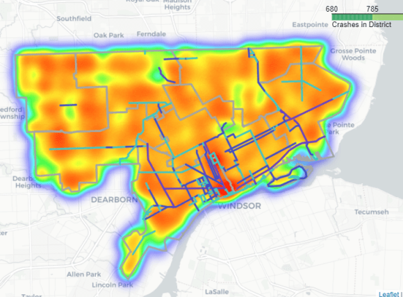
Also on the new website is a bicycle and pedestrian crash analysis — a report, slidedeck, and interactive mapping. This was just produced by a team from the University of Michigan School of Information. The team took state crash data, cleaned it up, and analyzed where the crashes were occuring. From the report:
Our data analysis led important discoveries around the existing safety issues per counsel district, specifically, how bikers are currently being impacted with districts. District 4, according to the data, had the most instances of biker injuries. It’s also worth noting that when a bike lane is present, accidents happen at a frequency a fraction of the time compared to instances of no bike lane with the point of contact being in the roadway.
Thanks to the team for this project and we look using this data to justify great investments that make Detroit streets safer for everyone.
 Long promised, finally here. Detroit has a bike and trail map again.
After many stops and starts, we finally got the funding we needed to complete the map and print 12,500 copies. Half of those have already been distributed at all the Detroit bike shops, runDetroit, the Lexus Velodrome, and Council member Scott Benson’s office at the Matrix Center. The Detroit Planning Department and Health Department also have copies they’ll be distributing at events across the city as will we.
The map shows all the current trails and bike infrastructure in Detroit as well as the Iron Belle Trail. It also include all the repair stations, bike shops, and kayak launches.
A substantial amount of effort went into including all the relevant laws pertaining to bicycling and pedestrians. Frankly, we’re not fans of the existing materials that fail to highlight laws motorists must follow around bicycles and pedestrians. We focus on those since they are the main determinant for improved safety. We also discuss the history of these laws, which were developed by the auto industry in the 1920s with no input from bicyclists.
The PDF of the map is available but it is a bit unwieldy. We’re going to work to get portions of it online in a more readable format.
Thanks to the DALMAC, the Office of Highway Safety Planning, and Michigan Department of Natural Resources for making this project possible.
 Registration is open for our 24-mile Joe Louis Greenway bike ride on Sunday June 23rd. The ride is being sponsored by the SmithGroup and will start near the Clark Park ice rink (1251 Scotten St.) at 8:30am.
This second annual Joe Louis Greenway bike ride will be limited to 100 donating participants. The objective of the ride is to create more awareness of the Joe Louis Greenway and raise money for the Detroit Greenways Coalition.
This year, participants will receive a commemorative pint glass!
From Christina Peltier, the City of Detroit’s Joe Louis Greenway Project Manager:
 The first series of the Joe Louis Greenway Visioning meetings will be taking place in the next few weeks. All four meetings have the same content and activities so no need to attend all four. Translation services will be available at Lasky Recreation Center and Patton Creek Community Center. Refreshments will be provided.
The Joe Louis Greenway is an approximately 31 mile pathway that will connect many of Detroit’s neighborhoods, people and parks. More information can be found here: www.joelouisgreenway.com
Please share the event poster and facebook page with you friends and neighbors.
Feel free to email me if you have any questions or if you would like me to present to your neighborhood organization.
 We have completed updates to a new Detroit bike and trail map and expect to have it printed and available later this month. We just received a $5,000 DNR Iron Belle Trail grant that will help us print the map. Of course the Iron Belle Trail will be prominently featured.
The map also contains a comprehensive list of rules and laws pertaining to bicycling, walking, scootering, and most importantly, safely driving motor vehicles around these other modes. We put a significant effort into this so that the focus is on motorist behavior, where we see the greatest room for improving safety on our roads and in our neighborhoods.
 Thanks to those that attended our recent fundraiser event at the Lexus Velodrome on April 20th. We saw some amazing track racing, especially among the junior riders. There’s a lot more racing throughout the year, so check their schedule.
|
|
||||
|
|
|||||


